
 CHAIN OF TITLE
R2226-0463
18th December 2018 Tax Claim Bureau Repository Deed
Harry Brindel and Rosemarie Brindel
To
Joseph Henry Associates LLC
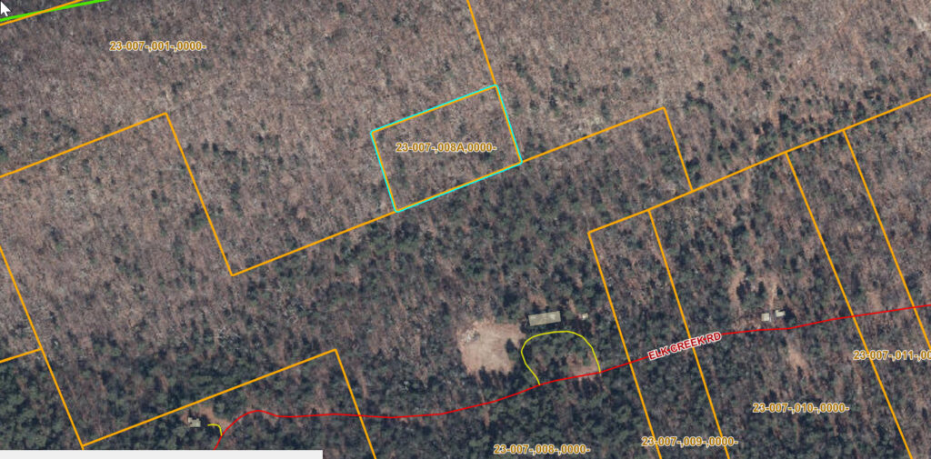
Tax ID Number: 23-007-,008A,0000-
Owner Name: BRINDEL, HARRY & ROSEMARIE
Deeded Acres: 2.00
Municipality: HAINES TOWNSHIP
Site Location: Route SR-0045 (North Of)
Assessed Value: 600
Fair Market Value: 1200
459:1039-41 — 23 Dec 1987
Paul W. and Mary J. Krape to Harry & Rosemarie Brindel
$0
Bounded:
North: by formerly O.J. Auman, now the Grantor,
South: Ray D. Stover,
East: C.S. Bower,
West: formerly F.S. Tomlinson, now the Grantor.
Acquired 270: 102.
270: 102-3 — 10 July 1963
John F. Knape to Paul W. Knape et ux.
$410.00
4 tracts
4. as above
Acquired 195: 622.
195: 622-24 – 24 April 1947
Matthew & Ruby Kelce to John F. & Mamie Knape
$30.00
N: O.J. Auman
S: Mabel Vonada
E: C.S. Bower
W: F.S. Tomlinson
Acquired: 28 Aug 1946
189: 24 — 28 August 1946
Commissioners of Centre County to Matthew Kelce
$1
2 acres, formerly Alfred & Peoria Lutz
189: 330 – 11 Dec 1944
Treasurer of Centre County to Commissioners of Centre County
$5.53
2 acres Alfred & Peoria Lutz
N: O.J. Auman
S: Mabel Vonada
E: C.S. Bower
W: F.S. Tomlinson
Owed $ 0.32 for 1942
Seated lands sold by Centre County Treasurer – 7 August 1944
2 acres – Haines – taxes due: $.32 – costs: $5.21 – Total: $5.53 – Supposed owners: Alfred & Peoria Lutz
To whom sold: County.
107:58 — 22 November 1915
Susan Stumpff to Oscar J. Auman — $21
Two tracts of timber land which T.G.W. Edmunds and his wife Augusta 23 March 1901 conveyed to Susan Stumpff, “subject to a reservation of two acres at the west end of the above described piece of land” described 85:134.
152:445 – 30 October 1915
Susannah A. Stumpff to William W. Wance
$150.00
Two tracts
85:134 – 23 March 1901
Thomas G.W. Edmunds et. ux. To Susan A. Stump
$1400.00
6 (or 7) parcels.
6. Haines Township
Begin at a stone, then by James P. Coburn, S 89° E 28 ½ p. to stone,
Then along Gap Road by Israel Weaver N 1 ½° 5.65 p. to stone,
Then along Hugh Wance N 89° W 28 ½ p. to stone,
Then along Thomas G.W. Edmunds S 2 ½° W 5.65p to beginning.
Reserving the right to cross by the Stover Water Route Company with the same “priviledge” now enjoyed by the said company.